by Yasmina Platt
Published in Midwest Flyer – Oct/Nov 2016
In the last issue of Midwest Flyer Magazine, I talked about developing “air trails” to give pilots (and their passengers) other reasons to fly and bring flying and tourism together. Whether you are a tourist in your own state or traveling out of state on vacation, these air trails offer a great combination of indoor and outdoor activities for all kinds of travelers. Last time we highlighted the Ozarks (in parts of Oklahoma, Missouri and Arkansas), and there are air trails available for New Mexico and Texas as well; however, this time, the Nebraska Department of Aeronautics, Nebraska Tourism Commission and I are highlighting Nebraska here.
Nebraska is a Midwestern state encompassing the prairies of the Great Plains, the towering dunes of the Sandhills, and the Panhandle’s dramatic rock formations. The “Cornhusker State” is known for its four seasons and friendly, hospitable residents, which is why I titled it “Nebraska Nice.”
While the Omaha skyline surprises visitors with its big city feel, part of the real beauty of Nebraska lies in its rural areas (especially while watching a sunset) that spread across the rolling plains.
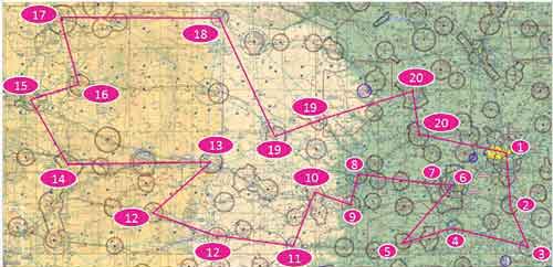
The proposed route is a circular one to make it easier to follow. We may have identified too many possible stops, but you can start/stop this route from any airport and fly it in any order or direction you prefer. You can also skip and add other stops as you please; these are just suggestions. Fly at your own risk! See attached route map.
In its entirety, the state of Nebraska has a far more dynamic topography than one would expect. While it may fit the mark of a “fly-over state” from FL350, it reveals at least four different types of terrain that stand out to those of us at lower altitudes.
The eastern part of the state starts with bluffs along the Missouri River that turn into the rolling hills of the “Bohemian Alps” west of Lincoln. If one flies north or south along the western edge of those hills, you can see where the edge of an ancient glacier once flowed (and flattened the middle part of the state).
The mid-portion of Nebraska is flat plains; however, there are numerous rivers running through the entirety of the state, which are interesting to follow.
The Sandhills’ territory starts about the midway point through the state, with hundreds of bodies of water filled by the Ogallala Aquifer.
The Western portion (Panhandle) has the greatest amount of hills, bluffs, and the beginnings of mountainous terrain. Whether flown from east to west, or west to east, the Panhandle of Nebraska is a striking beginning or end of an enjoyable air tour of this great state.
To read the details of the Nebraska Air Trail or any of the other air trails, visit www.airtrails.weebly.com. If you decide to fly part or the entire route and use social media, we would love for you to use #NebraskaAirTrail as a hashtag.
Fly safe, fly often, and enjoy the air trails!
EDITOR’S NOTE: Yasmina Platt is an accomplished pilot and former manager of AOPA’s Central Southwest Region. She now works for AECOM – a global leader in airport infrastructure development providing planning, design, construction, operation, and management support services to a wide range of clients.

