by Michael J. “Mick” Kaufman
In the February/March 2016 issue of Midwest Flyer Magazine, my column entitled “Which George is steering the airplane” landed me several emails and phone calls, so I will respond to some of this feedback in this issue. Also, our topic of the “homemade”ADS-B receiver I built has been well received by pilots wishing to save hundreds of dollars over manufactured receivers, so we have an update on that system, as well. In addition, I spoke with Don Houtz of Skyguard TWX, and have more information to share on that portable ADS-B transceiver (in and out), which has been approved for use in “experimental” and “light sport aircraft,” but not yet for “certified” aircraft. In a recent FAA ruling on ADS-B out units, some changes were made in the rules to allow non-TSO’d ADS-B transceivers to be used in experimental and light sport aircraft, providing they meet certain performance minimums and installation criteria.
One of our readers, Dan Vogt of Omaha, Neb., has asked about the firmware update on the Garmin 430/530 boxes that I mentioned in the last issue. To clarify, I first want to mention that this firmware update was done many years ago, and if your radios have seen a radio shop for any reason, the technician has probably done this update. This update will only affect non-RNAV/GPS approaches.
With the advent of GPS “roll-steering” (GPSS), pilots liked it so much that they chose to fly it, rather than the analogue (localizer) signal that the FAA intended to be flown.
For example, on a localizer approach, the GPS side of the Garmin 430/530s provided a localizer signal, as well as a GPS signal for the entire portion of the localizer approach before the update. Seeing GPS/roll steering did a better job of maintaining the course than did the analogue “approach mode” of the autopilot, pilots decided to use the GPS information for guidance, rather than the localizer that the FAA had intended, afterall, this is a “localizer approach” and not a GPS approach. From time to time manufacturers, such as Garmin, make changes to their units when there appears to be a problem; in this case pressure from the FAA to keep pilots flying the localizer signal on a localizer approach. As I pointed out to Dan, it makes no difference as to which autopilot or GPSS unit is in the airplane…this is strictly a Garmin 430/530 issue.
If you have this update on your 430/530, it only affects non-GPS approaches and does so by shutting off all GPS navigation from the Final Approach Fix (FAF) to the Missed Approach Point (MAP). On the Icarus GPSS unit, with the optional voice turned on, it will annunciate “GPSS disengaged,” and on other units like the DAK and S-TEC GPSS units, the light on the engaged button will flash. If we as pilots fail to switch to the approach mode on our autopilot, “No George” is flying the airplane. Once the airplane has passed the Missed Approach Point, the Icarus GPSS unit will announce “GPSS engaged” and the DAK and other similar units will stop flashing and return to a solid “on” light.
If your aircraft has not seen your radio shop and received this update, I still encourage you to follow the FAA procedure of flying a localizer approach using the localizer and not the GPS signal.
The next time you are doing a proficiency flight, and if you have this type of equipment, try a localizer approach and note the results to see what firmware you have. I don’t recall the update version, so please drop me an email and we will sort it out in a future column.
A side note for those with the Icarus GPSS (my favorite GPSS unit), keep that voice enunciator turned on….it is a great assistant and could keep you from an accident, as many of us would not have caught a flashing light in our field of vision.
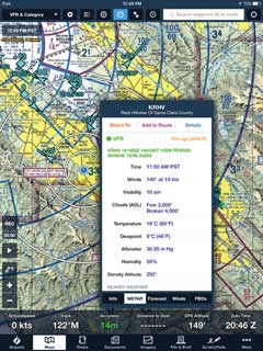
Next, I have heard that several of our readers have built the “homemade” ADS-B receiver (my column, February/March 2016 issue, Midwest Flyer Magazine) with great results. Jeff Lane of Milwaukee, Wis., and Jim Guneisen of Palo Alto, Calf., have built the units successfully. Roger Shadick of Eagle River, Wis., was contemplating building a unit, but really wanted an AHARS in his unit. Jim had sent me a screen shot from his Foreflight program on his iPad showing a weather and traffic display he received on the ground from his unit (FIG-1). Most of the ground-based Universal Access Transceiver (UAT) ADS-B stations are co-located on cell towers. You may be fortunate enough to get a signal on the ground as Jim did, as the average distance is 4 to 5 miles based on terrain for a signal on that frequency.
Mark Phillips of EAA Chapter 551 in St. Cloud, Minnesota, will be building these receivers, and there is now an AHARS option available for an additional $40.00, which will be great news for Roger. More great news on the ADS-B box is that Wing X Pro 7 version 8.6.3 is now providing support for this ADS-B receiver or “Stratux” in their software, as well as AHARS support.
As the deadline for ADS-B out compliance is getting closer, it may seem hard to believe we have been working on this project for more than 5 years now. In a recent quote I received to equip my V-tail Bonanza, the numbers came in at $7,361.10 to bring my aircraft to compliance with a TSO’d ADS-B in and out unit. This price may seem high to those who have not gotten a recent quote, but it is very much in line with other quotes I have seen. It is important to remember that I do not have a transponder that is upgradable, like the Garmin 330, which can be ADS-B out upgraded for around $2,000.
In the June/July 2013 issue of Midwest Flyer Magazine, I wrote an article on the evaluation of the Skyguard TWX ADS-B in/out transceiver, and again mentioned it in the last issue. I had since had the chance to speak with Don Houtz of Skyguard again and got an update.
For years pilots had been learning about altimeters and how they work and the errors associated with them and now we have another; “GPS altitude,” to add to our aviation vocabulary. As a quick review, we have heard many of these terms: *pressure altitude, **true altitude, ***absolute altitude, ****indicated altitude, *****density altitude and now ******GPS altitude (see notes below). Your instructor may have used this phrase in one of your ground school classes: “When going from high to low, look out below,” which applies to flying from an area of high pressure to low pressure and also high temperature to low temperature. So now we have GPS altitude and with WAAS it may seem to be the best way to go as it has proved to be quite accurate.
When I tested the Skyguard TWX three years ago, it used a GPS to broadcast its altitude, which was not in sync with the other units that were transmitting pressure altitude, and even though close most of the time, the FAA would not buy into it. The new Skyguard TWX has added another receiver that intercepts the pressure altitude provided by the aircraft’s encoder and is then transmitted by your current 1090 mode C transponder to provide the pressure altitude for the ADS-B out altitude. In the FAA’s ADS-B rules, it makes note that if you choose to transmit your ADS-B out on 978 MHZ, referred to as UAT (Universal Access Transceiver), you must keep your old mode C transponder. The reason is that the government, the airlines and many general aviation aircraft have invested a fortune in Traffic Collision Avoidance Systems (TCAS), and it would make that system useless, as it only sees 1090 transponders. This is all covered in Advisory Circular 20-165A, as well as TSO-C154c and TSO-C166b for current certification and installation standards for ADS-B out. After speaking with Don, he informed me that the FAA ruling now allows the Skyguard TWX to be permanently installed in experimental and light sport aircraft providing the light sport aircraft manufacturer provides a letter authorizing this installation. I am hoping that we see some relief for owners of certified aircraft in the future, as well.
Spring flying is just around the corner and that means thunderstorms.
Fly safe!!!!
Notations:
*Pressure Altitude (read from your altimeter when set to 29.92 hg).
**True Altitude (This is the height above mean sea level).
***Absolute Altitude (This is your height above ground, measured with a radar altimeter).
****Indicated Altitude (Altitude read from the altimeter with correct barometric setting).
*****Density Altitude (Pressure altitude corrected for non-standard temperature).
******GPS Altitude (Altitude read from a GPS, above mean sea level).
EDITOR’S NOTE: Michael J. “Mick” Kaufman is a Certified Instrument Flight Instructor (CFII) and the program manager of flight operations with the “Bonanza/Baron Pilot Training” organization. Kaufman conducts pilot clinics and specialized instruction throughout the U.S. in a variety of aircraft, which are equipped with a variety of avionics, although he is based in Lone Rock (KLNR) and Eagle River (KEGV), Wisconsin. Kaufman was named “FAA’s Safety Team Representative of the Year” for Wisconsin in 2008. Email questions to captmick@me.com or call 817-988-0174.


