Learn How WisDOT’s Bureau of Aeronautics Improves Flight Planning
by John Thivierge
Director of Aviation Weather
Schneider Electric
Flight conditions can change in the blink of an eye. One moment you’ll see clear blue skies and feel the hot summer sun. The next moment, you may notice developing clouds and distant lightning flashes — and soon find yourself looking for a place to land.
In any season, particularly in the Midwest, fast-changing weather can impact your flight plan. Have you ever checked conditions for an upcoming flight, expecting light winds and minimal turbulence, only to discover developing thunderstorms and high winds? Such changes not only require you to be on alert, but may also require adjustments to your flight plan.
Weather — An Industry Issue
Weather is the most significant factor in aviation safety and operational efficiency, causing more than 20 percent of all accidents and more than 70 percent of all delays worldwide. Having access to customized, real-time aviation weather technology in advance of your flight is a must. As conditions change, your ability to make safe decisions is affected. The key is having accurate, around-the-clock aviation weather data at your fingertips.
“Weatherizing” The WisDOT Bureau of Aeronautics
On any given day, the Wisconsin Department of Transportation (WisDOT) supports a network of eight commercial service airports and 90 diverse general aviation public-use airports in the state. These airports provide worldwide access to Wisconsin’s communities for personal travel, business, tourism, emergency responders, agricultural spraying, and flight training.
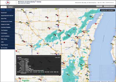
The AviationSentry™ homepage can be used to easily show radar, satellite, METARs, and more in one place.
To support better flight decisions and assist in the WisDOT Bureau of Aeronautics’ mission of improving aviation safety, Schneider Electric’s AviationSentry™ is now available to all Wisconsin pilots. This solution is a stand-alone, Internet-delivered weather system designed exclusively for the aviation industry. With it, you can view radar, satellite, winds, observed weather, storm corridors, lightning, and more, down to airport views. Within the United States, you can see real-time National Weather Service watches, warnings, and advisories, including areas of maximum impact. Even Temporary Flight Restrictions (TFRs) can be displayed as layers to show you all of the restricted airspace impacting your flights — plus you can click “get details” for full text information.
Weather Is Need-To-Know Information For Safe Flying
AviationSentry provides Wisconsin pilots with the most accurate forecast information available, ensuring safe and accurate flight decisions. Its speed and convenience helps you thoroughly plan for the weather at hand. With its advanced aviation weather tools, you’ll know if a flight needs to be rerouted, delayed, or cancelled due to developing severe weather.
Flight Hazard Tracking: The Big Picture
Our enhanced flight hazards forecasts include thunderstorm, turbulence, icing, and lightning forecasts for a very precise area and time period. This allows you to get ahead of the storm by viewing weather hazards like snow, ice, severe thunderstorms, hail, lightning, and even tornado cells before they impact a flight.
Turbulence Forecasts
Our enhanced flight hazards model offers full, state-of-the-art Eddy Dissipation Rate (EDR) turbulence forecasts. It provides an integrated view of the four kinds of turbulence: boundary layer, clear air, mountain wave, and convective. Specific EDR values are provided, and can be applied to any aircraft’s airframe-specific thresholds. They are also specific to several flight levels, from 050 to 530 feet.
Icing Forecasts
Today’s icing forecasts are typically “one size fits all.” This can create a lot of ambiguity as to when a particular aircraft might be more vulnerable to icing than those forecasts indicate.
Our enhanced flight hazards forecasts include aircraft-specific icing forecasts that use a universal, objective quantitative metric to calculate aircraft performance loss. This is then applied to ice accumulation for specific airfoils. Categories are based on aircraft type: small, medium, and large — allowing you to better view icing conditions in relation to your aircraft. We also provide guidance to help classify specific aircraft into these three categories.
Thunderstorm Forecasts
Thunderstorms can create intense turbulence and icing. Avoidance is the best strategy, and accurate forecasts can help.
Our enhanced flight hazards forecasts include thunderstorm forecasts for a very precise area and time period. As with our turbulence and icing forecasts, we offer hourly forecast periods to support enhanced flight planning and following — both before and after departure.
We also provide maximum top values that indicate the top most altitude forecasted for that area of thunderstorms, as well as insight into the intensity of the storms measured in meters-per-second of vertical velocity. Convective turbulence and icing are best correlated to storm draft speeds or vertical velocity; the larger the updraft velocity, the more intense the accompanying turbulence and icing.
World-Class Weather Data Accuracy
The problem with generic weather information from the Internet is that it may not be up to date or location-specific. AviationSentry’s real-time, accurate, and customizable weather tools allow you to select your own parameters for targeted information. Radar images are updated every five minutes, and it uses a combination of computer models and value-added assistance from an in-house team of meteorologists to produce accurate forecasts out to five days.
AviationSentry utilizes the meteorologist’s expertise and models to crunch thousands of bits of data, apply the laws of meteorology, and then deliver short and long-range forecasts. This type of weather information is far more accurate and detailed than the general information found on the Internet, television, or radio.
The “How To” of Planning & Filing A Flight
A one-stop-shop, AviationSentry not only helps you accurately determine weather conditions, it also assists in flight planning and filing. To plan a route, simply drag the mouse across the map, pointing and clicking on your starting and ending points. The system collects current and developing weather data for the flight and works to determine a fast, safe route for you. Filing the flight plan is done via a DUATS interface, which is accessed by a toll-free number. Through the entire process, a convenient “weather en route” button indicates weather information along the flight, from departure to destination. You can access this information at any time for additional details.
Home User Access
Weather information for FAA-certificated pilots in Wisconsin is conveniently available on your computer with the new WisDOT home users’ system. This home weather briefing service is available through the department’s website at http://wisconsindot.gov/Pages/travel/air/pilot-info/weath-acc.aspx.
Click the link for AviationSentry and it will take you to the registration page to sign up for access. A password will be emailed to you after you complete the registration process. Then you can begin accessing complete weather information from your computer.
You’ll Notice The Difference
Our top aviation weather scientists are dedicated to bringing you enhanced forecasts that easily integrate into your flight planning operations. You’ll notice how the comprehensive, real-time information, forecasts, and hazard alerts help optimize your safety and efficiency.

