
by Nate Sievert
Airport Operations Program Administrator – MnDOT Office of Aeronautics
Published in Midwest Flyer Magazine August/September 2022 Digital Issue
Airports around the world provide pilots – and the general public – with current weather and climatology information to ensure safe and efficient aviation operations. While many pilots refer to this weather information system as an Automated Surface Observing System (ASOS), in this article we will be discussing the specifics of an Automated Weather Observation System (AWOS).
Nearly all pilots are familiar with the METAR (Meteorological Aerodrome Report), which is the automated system that provides pilots and others with all the weather information for a given AWOS site. The METAR is based on the information collected by the AWOS weather station and includes information from visibility to wind speed. A METAR is broadcast over the airwaves and distributed over the internet.
A METAR typically looks like this example:
METAR KANE 151519Z AUTO 21008KT 10SM CLR 04/M02 A3018 RMK A02
Parts of an AWOS
There are many systems and sensors that come together to create an AWOS system that provides the information in a METAR.
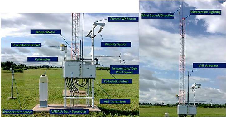
The photo above shows most of the major components that come together to create a functional, accurate, state-owned AWOS that provides METARs from airports in Minnesota. There are eight major components, discussed below.
One of the major components is the wind speed/direction sensor that sits atop the main tower of the AWOS system. That sensor is equipped with a wind vane and cup system that measures wind direction in degrees, along with windspeed in knots. In the METAR example above, this information is provided as “21008KT,” which means the wind is at 210 degrees, at a speed of 8 knots.
Following the wind information in the METAR is the “site visibility.” Site visibility is provided by the kindly-named visibility sensor located on the side of the system’s base. The visibility sensor uses infrared light to measure visibility in statute miles. In the METAR example above, site visibility is indicated by “10SM.”
The next two sensors are more specific to the types of weather the general population is familiar with, like rain and snow. The present weather sensor (or “WX”) can differentiate seven different types of precipitation, while the thunderstorm sensor detects changes in the local electrical field to determine lightning strikes. These sensors give information such as SN in our METAR above, which indicates “snow.” Other conditions the WX sensor measures and broadcasts through METARs include:
– RA, Rain – SH, Showers – SN, Snow – GR, Hail – BR, Mist – FG, Fog – FZ, Freezing Rain
Pilots also rely on AWOS systems to measure “cloud cover.” The AWOS’s ceilometer calculates cloud height with a laser that can reach up to 25,000 feet above the ground. The ceilometer calculates the average cloud cover over 30 minutes to determine the current cloud ceiling. When there are no clouds – like in our example METAR – the METAR would broadcast “CLR” for clear. If there were clouds, the AWOS would produce a METAR that looks something like “OVC008” which indicates “overcast clouds at 800 feet.”
Following the cloud cover information on the METAR is the “temperature and dewpoint” readings. In our METAR example above, those readings are broadcast as “04/M02,” which means the temperature is 4 degrees Celsius, and the dewpoint is -2 degrees Celsius. The temperature and dewpoint sensor hangs off the side of the main component box of the AWOS. This sensor gathers the information while processing a multitude of equations before broadcasting the temperature and dewpoint readings.
The final component that is an integral part of the METAR is the “barometer” which provides an altimeter setting in inches of Mercury. The altimeter setting is calculated using barometric pressure, site elevation, and air temperature. The METAR example above gives the altimeter setting “A3018.”
There are many other pieces of equipment that are needed to make an AWOS run efficiently and correctly that aren’t necessarily mentioned in the METAR itself.
Data Display and Resources
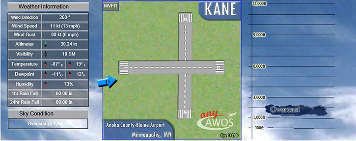
Beyond the METAR, the information from the AWOS is broadcast to many different outlets at the airport, and online. At the airport, a direct data feed runs from the AWOS to a display in the airport’s arrival departure building. That display provides a live feed of current weather.
The AWOS data is also uploaded online to www.anyawos.com. Minnesota currently has 79 AWOS systems live on anyawos.com, and each system may be found using the associated airport’s identifier – for example: www.anyawos.com/KANE. An example of the interface is shown below:
Minnesota’s statewide AWOS system, and the METARs it generates, are vital to pilots, a safe aviation system and others outside of aviation who use AWOS information in their work. The many components and subsystems of an AWOS cohesively create and display a great amount of weather data. Pilots and the public can use AWOS to stay informed, stay safe, and remain aware of current conditions with accurate and current data.
To see current weather information at Minnesota’s airports for free online, visit
mndot.gov/aero/navigationsystems/awos-map-online.html