
 by Matt Lebens
Airport Development Engineer, North Region – MnDOT Office of Aeronautics
Published in Midwest Flyer Magazine October/November 2022 Digital Issue
An Airport Layout Plan (ALP) is a formal public document required by MnDOT and the Federal Aviation Administration (FAA), and consists of a set of large format (24” x 36”) detailed overhead drawings of the entire airport. ALPs are important because they give airport managers and others a comprehensive and accessible picture of airport infrastructure that helps provide a long-term, comprehensive planning strategy. ALPs may be prepared in conjunction with, and in support of master plans, long-term comprehensive plans (LTCPs), and zoning documents. The Narrative Report or Master Plan that typically accompanies the ALP provides detailed information about current and projected activity levels at the airport, facility requirements, alternatives and recommendations, and an implementation plan.
There are somewhat different ALP requirements in Minnesota depending on whether the airport is in the federal system, or the airport is state funded only. Airports in the FAA Report, National Plan of Integrated Airport Systems (NPIAS), need to meet all state and federal rules and design criteria. Non-NPIAS airports in Minnesota must prepare ALPs according to state guidelines. Individual layout sheets that comprise the airport layout plan set will vary with each planning effort. Drawings that might be included are described below:
• Title Sheet – A separate cover sheet, with approval signature blocks, airport location maps, and other pertinent information.
• Airport Data Sheet
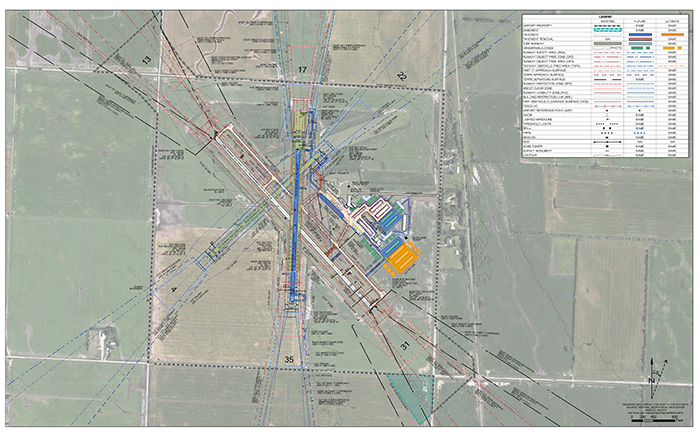
• Airport Layout Plan – Shows the entire airport and depicts details of the existing and future airport facilities. (See example below.)
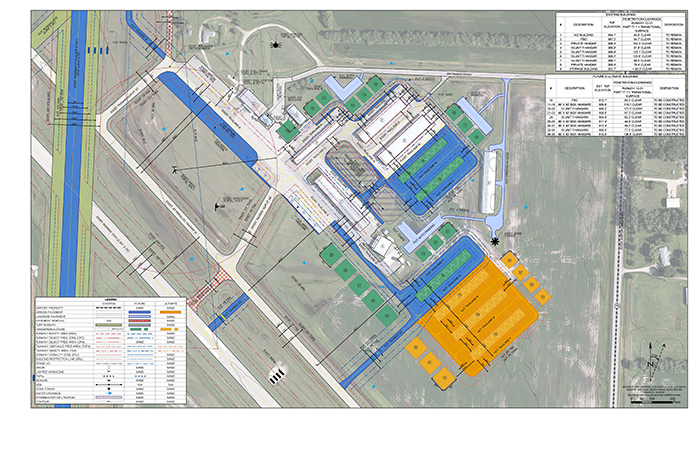
• Terminal/Building Area Drawing – Shows all existing or planned buildings and related infrastructure. It is used to review safety, security, and funding eligibility. (See example below.)
• Inner portion of the approach surface drawing – Shows details of the approach surfaces and other zones, such as those required by the local FAA office or state agency, runway protection zone, clear zone, Zone A, etc.
• Airport Airspace Drawing
• Zoning/Land-Use Drawing
• Airport Property Map/Exhibit A Sheet
ALP drawings typically show the airport as it exists today, plus near-term plans (0-5 years), long-term plans (6-10 years), and potential development plans (11-20 years). The ALP includes the facility’s graphical plan layout with design and operational data, airspace information required for aircraft approach and departure procedures, building area graphics and meteorological data, as well as property and land-use information for the airport and surrounding area. That information is important, as it is used to develop and implement airport licensing, safety zoning, and community land-use requirements.
On average, it takes approximately two years to complete an ALP and they are typically updated every five to 10 years, depending on the airport’s classification and development needs. Current, well-prepared, and approved ALPs are vital for safe, effective operations and development of Minnesota airports. An approved ALP ensures the safety, utility, and efficiency of the airport, helps plan and deliver maintenance and improvement projects that meet design standards, and are required for public funding. Up-to-date airport planning documents allow better funding decisions for each airport, and across the entire aviation system.
In order to prepare an ALP, a consultant is typically tasked by the airport sponsor to prepare the document. ALPs require coordination between the Airport’s sponsor, consultants, FAA, MnDOT Aeronautics office, airport users, key stakeholders, and public involvement activities. There will be a review of the airport’s existing conditions, determination of current and future airport “design aircraft,” fixed based aircraft, and operations forecasts, determination of facility needs, evaluation of potential alternatives, and estimates of capital costs and phases. Good communication between all stakeholders is a critical component to creating a quality ALP. Pilots and other users can contribute by reporting any perceived unsafe or inefficient operational conditions to the airport manager or the MnDOT Aeronautics office. We’re always open to new ideas, and welcome input from those who use our airports to help keep infrastructure safe, well maintained, and functional for pilots and the local community.
Developing an ALP, and their associated reports, is a collaborative effort that involves the airport sponsor, airport users, the surrounding community, and State and Federal agencies. A quality ALP provides the necessary information to maintain a safe, cost-effective airport – one that creates and enriches economic and recreational opportunities for the community it serves, for years.
EDITOR’S NOTE: Matthew Lebens is the P.E. Principal Engineer for the North Region with the MnDOT Office of Aeronautics, Airport Development Section. He started working at MnDOT in 1987. He graduated from the University of Minnesota in 2004 with a degree in Civil Engineering. He started at Aeronautics in 2015 and has been working continuously in the North Region since then.