

Cornbelly’s Photo
by Yasmina Platt
Published in Midwest Flyer Magazine December 2022/January 2023 Digital Issue
Fall is upon us and, with that, come corn mazes amongst other things! Let’s talk about some of the awesome things we, pilots, can see from the air that others don’t have the privilege to!
Visit Atchison Photo
I must start with the Amelia Earhart earthworks outside of her hometown of Atchison, Kansas. This beautiful 42,000 sq ft art site was created by Stan Herd in 1997. It was constructed on a hillside overlooking Warnick Lake, with a viewing deck. Coordinates to punch on the GPS: 39°32’15.5″N 95°08’42.6″W.
USA Today asks readers for their top 20 corn mazes every year and then 10 of them are selected for the “Best Corn Maze” award. This year, these are the top 10:
1. Treworgy Family Orchards – Levant, Maine
2. Devine’s Corn Maze & Pumpkin Patch – Harrodsburg, Kentucky
3. Cherry Crest Adventure Farm – Ronks, Pennsylvania
4. Davis Mega Maze – Sterling, Massachusetts
5. Denver Downs Farm – Anderson, South Carolina
6. Great Vermont Corn Maze – Danville, Vermont
7. Exploration Acres – Lafayette, Indiana
8. Cool Patch Pumpkins – Dixon, California
9. Maze Craze – New Springfield, Ohio
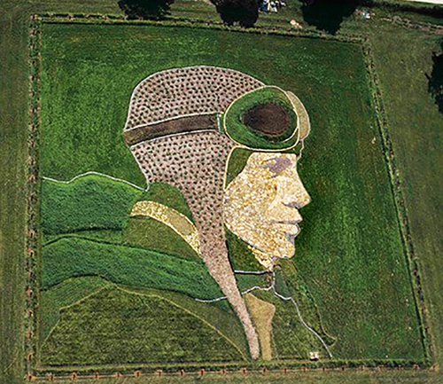
10. Cornbelly’s – Lehi, Utah
This past September, we spent the majority of our (free) time in the Salt Lake City valley. Cornbelly’s corn maze just south of SLC is probably my favorite of this year’s top 10. Coordinates: 40°25’32.3″N 111°53’32.3″W. I love the message of “Never grow up” and the fact that Peter Pan can fly. I mean truly fly! If only we could too, huh?
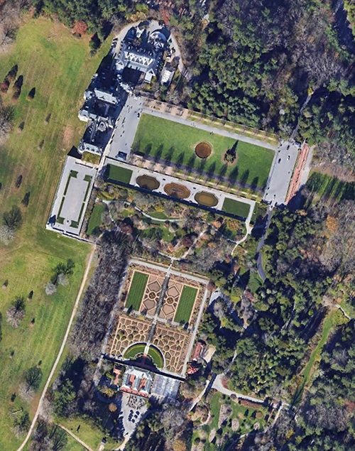
Like corn mazes, the design of some of the best gardens around the world is best observed from the air. One of my favorites in the U.S. is Biltmore’s in Asheville, N.C. Coordinates: 35°32’25.5″N 82°33’05.6″W.
Architecture is often looked at from a frontal/side angle, but many of the old architecture is best admired from the top. I’m using the Ciudadela de (or Cidatel of) Jaca in my beloved Spain as a good example of this. In addition to being a military fortress, it was also used as a prison. The fortress has a five-pointed starry plan and is preserved practically intact since its construction. Coordinates: 42°34’20.9″N 0°33’08.2″W.
But, if you’ve read many/any of my prior articles, you know National Parks are some of my favorite places to visit and enjoy. So, with that in mind, I can’t leave a magical place like Yellowstone out of this list. Grand Prismatic Spring is honestly best seen from the air but plan any possible emergency wisely near it just in case… bubbles and burning water! Coordinates: 44°31’30.2″N 110°50’17.5″W. If you can’t fly over it, the second-best place to see it from is the overlook across from it, but this requires a short walk from the Fairy Falls parking lot. However, keep in mind it’s hard to see it in the winter. I honestly didn’t realize it until I visited it this past February. The air is so cold, and the water is so hot that a cloud of steam is created, making it difficult to see the eye of the spring.

Another unique site that can only be seen once a year is Nevada’s Black Rock City, where tens of thousands of people gather to celebrate Burning Man. The metropolis, dedicated to community, art, self-expression, and self-reliance, continues to grow year after year and, eventually, it will complete the full circle. Coordinates: 40°47’11.0″N 119°12’23.4″W.
I’ll end with the most unique place I’ve ever seen from the air: Peru’s Nazca Lines. The Nazca Lines are a collection of giant geoglyphs (designs or motifs etched into the ground) created by the ancient Nazca culture (which began around 100 B.C. and flourished from A.D. 1 to 700). These lines (some of which are 30 miles long), geometric designs, and pictorial representations (which can measure up to 1,200 feet) were designated a UNESCO World Heritage Site in 1994 and are still a mystery to researchers despite having been studied for over 80 years. If you don’t take to the skies, you can’t really see them! Giving you only one coordinate does not do this large area justice, but here are the coordinates for the tree in the provided picture to get you started: 14°41’37.6″S 75°06’51.9″W. FMI, visit www.airtrails.weebly.com.
Fly safe and fly often! Have you flown over any of this year’s Top 10 Corn Mazes? Send me a note with some of your favorite places to see from the air.
ABOUT THE AUTHOR: Yasmina Platt’s full-time job has her planning the future of aviation infrastructure for Joby’s electric Vertical Takeoff and Landing (VTOL) aircraft. She also writes an aviation travel blog called “Air Trails” (www.airtrails.weebly.com), in addition to articles on pilot destinations for Midwest Flyer Magazine. Pilots can locate articles Yasmina has written by going to www.MidwestFlyer.com and typing “Yasmina” in the search box, or by going to the “Archives” section, then “Columns,” then “Destinations.”