
by Hal Davis
WisDOT Bureau of Aeronautics
Published in Midwest Flyer – June/July 2019 issue
As is the case across the country, most airports in Wisconsin were built during or shortly after World War II. The majority were built in areas that were then on the outskirts of towns, where land was cheap and plentiful. As towns and airports grew over the next few decades, and radio and telecommunication towers became more prolific, conflict became inevitable. Fortunately for aviators, the Wisconsin legislature has given airport owners overarching authority to protect and preserve airspace within three miles of their airports. Height limitation zoning ordinances (HLZO) are one of the strongest tools available to a municipal airport owner to protect the airport and its airspace.
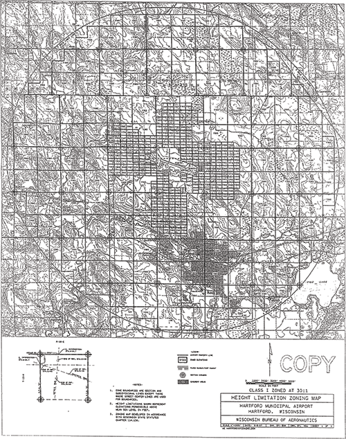
An HLZO is made up of two parts: the ordinance language and a map. The language describes the scope of the restrictions, while the map identifies the exact height restrictions for specific areas. In general, the height restrictions were designed to provide the maximum protection under state law with little regard for the actual protection needed for the visual and instrument procedures at a given airport. In other words, HLZOs were often more restrictive than needed. Great news for aviators…not so great news for developers.
The HLZO maps were drawn utilizing a two-dimensional grid to protect a three-dimensional surface. Today, advances in technology and data availability provide an enormous opportunity to improve HLZO maps.
Enter geographic information systems (GIS). Much like Google Maps and ForeFlight have all but done away with paper maps, GIS has rendered traditional HLZO maps obsolete as well. Utilizing GIS for HLZO maps has significant advantages over traditional HLZO maps. Instead of requiring a magnifying glass to decipher traditional HLZO maps, GIS allows the user to pan and zoom around the map. Utilizing aerial imagery as the base map increases the usability of the map, making it much easier to locate a precise location.
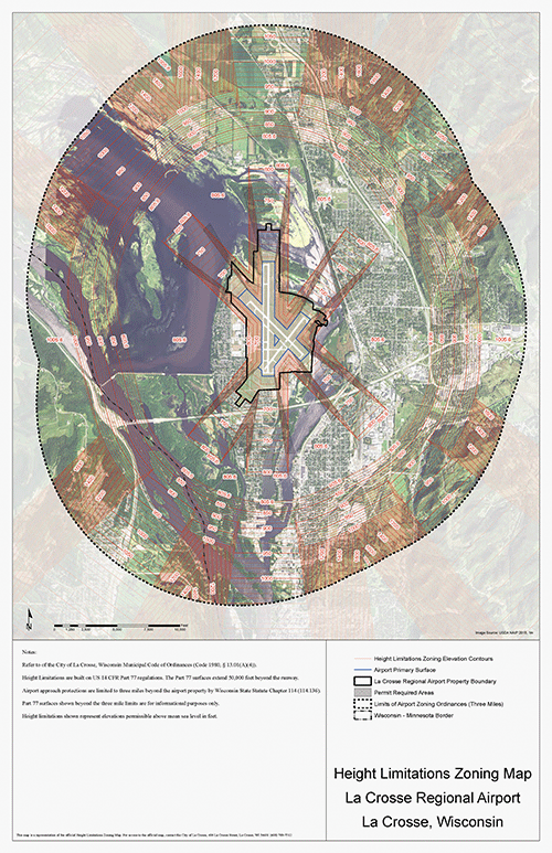
Many cities and counties already have public GIS-viewers that can make the map more accessible than ever. This means fewer phone calls to the airport manager from developers and easier evaluation of potential impacts. Simply converting an airport’s existing HLZO map to GIS would allow the airport to benefit from these advantages.
Some airport owners have also leveraged GIS to improve the height restrictions as well. For instance, several airports have replaced the traditional grid design with contours that more closely match the slope and dimensions of the airspace specific to that individual airport. This method allows the airport owner to focus on protecting the airspace that is most critical, as well as improve the developability of surrounding land, benefiting the community as a whole.
Pressure to develop near the airport will only increase as time goes by. Take the time now to make sure your HLZO protects both the existing and future airspace needs of the airport; establish communication between airport management and local zoning and permitting departments; and utilize GIS to make your map user-friendly and widely available. Your future self, airport users, and developers will thank you.
For assistance converting traditional HLZO maps to GIS, contact Brenda Hanson at BrendaE.Hanson@dot.wi.gov. For general assistance with HLZOs, contact me at Howard.Davis@dot.wi.gov.