
by Luis E. Canelon-Lander
MnDOT Navigation Systems Radio Engineer
Published in Midwest Flyer Magazine October/November 2023 Digital Issue
As a new member of the Navigation Systems team in the Office of Aeronautics, I want to take a moment to go over the basics of NAVAIDs, their importance in ensuring safe aircraft operation, and highlight the ongoing commitment of MnDOT Aeronautics to maintaining and improving this vital part of our state’s aviation infrastructure.
First, the term “NAVAIDs,” refers to aviation navigational aids. A wide range of NAVAID devices provide precise navigation and position details by transmitting visual, audible, and radio frequency signals to aircraft and, ultimately, to pilots.
Minnesota has made a significant investment in creating one of the most comprehensive NAVAID systems in the country, and currently MnDOT Aeronautics manages the largest network of non-federal NAVAIDs and weather reporting stations in the United States. This network encompasses over 530 pieces of equipment at airports, heliports, hospitals, and seaplane bases throughout Minnesota. However, some of that equipment and components are beyond their useful life and require continuous maintenance and support.
Today’s flying public heavily relies on NAVAIDs and weather reporting for safe navigation. Some examples of NAVAIDs owned and maintained by MnDOT Aeronautics include:
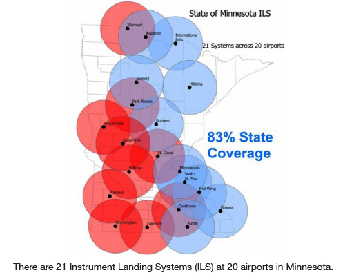
• ILS (Instrument Landing System): A highly accurate system that enables pilots to land safely on the runway, even during poor visibility. MnDOT Aeronautics maintains 21 ILS systems at local municipal airports throughout the state. Each ILS consists of a localizer and glideslope, which offer precise horizontal and vertical guidance to the aircraft and pilot during landing.
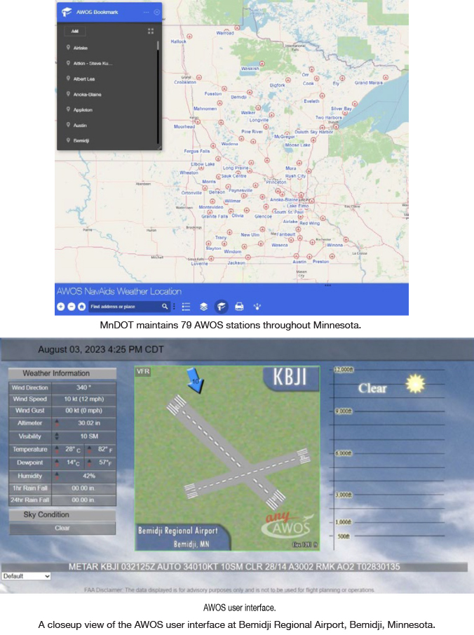
• AWOS (Automated Weather Observation System): A local weather reporting system with multiple sensors that automatically collects and reports atmospheric and other weather data and provides information to pilots (and other users) about weather conditions at the airport. This information includes temperature, dewpoint, wind speed and direction, altimeter, visibility, and ceiling data with sky conditions such as cloud heights and density. MnDOT maintains 79 AWOS stations throughout Minnesota. In addition to serving the flying community, meteorologists and others use the AWOS network for weather reporting, forecasting, and emergency management.
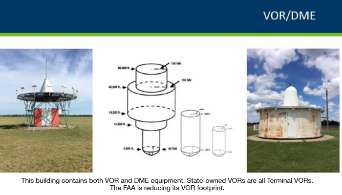
• VOR/DME (VHF Omnidirectional Range / Distance Measuring Equipment): A navigation system commonly used in aviation to determine the aircraft’s position by providing the bearing and distance from the VOR station to the aircraft through high-frequency radio signals. The VOR/DME navigational system helps pilots determine their position, track their course, and navigate toward a specific destination. Alternatively, VOR/DME is a navigational system backup available to pilots if GPS fails. MnDOT Aeronautics maintains six VOR/DME navigational systems.
• GCO (Ground Communication Outlet): These are unstaffed and remotely controlled ground-to-ground communication devices that allow pilots to contact Air Traffic Control and the Flight Service Station using a VHF radio to a telephone connection. This communication is essential for various purposes, such as obtaining clearances for takeoff, receiving air traffic control instructions, requesting weather updates, reporting emergencies, and updating flight plans. MnDOT Aeronautics maintains 20 GCOs throughout the state.
• RCO (Remote Communication Outlet): These devices extend the Flight Service Station’s range by receiving the messages and relaying them automatically between pilots and the Flight Service Station. They are remotely controlled by air traffic personnel. MnDOT Aeronautics maintains two RCO systems.
• MALSF/MALSR (Medium Intensity Approach Lighting System with Sequenced Flashers / Runway Alignment Indicators): These runway lighting systems assist pilots during approach and landing. They provide essential visual aids to align the aircraft with the centerline of the runway and are especially important during low visibility conditions. MnDOT Aeronautics maintains 21 MALSF/MALSR systems.

• MNWAS (Minnesota Weather Access System): Minnesota’s 133 local public airports have at least one MNWAS computer in their terminal buildings. These are publicly accessible computers where pilots can access weather updates, flight information and briefing tools. Additionally, pilots can directly inform MnDOT Aeronautics of any problems they encounter with NAVAID devices, facilities, runways, or the airport environment through the resources provided on the MNWAS computer.
The network of NAVAID devices listed above serves nearly all of Minnesota’s public airports, from smaller general aviation airports with turf runways, to bigger commercial service airports like Bemidji Regional Airport (KBJI). As previously noted, much of the equipment is approaching or has exceeded its useful life. Yet, the equipment still needs to be maintained. For the oldest equipment, numerous components are obsolete and no longer readily available, which makes maintaining those systems increasingly complex. MnDOT Aeronautics intends to continue supporting the existing infrastructure by fixing outdated equipment in the short term, while replacing at least six ILS, 40 AWOS, and one VOR within the next five years.
To report a problem or concern with a NAVAID device at a public airport in Minnesota, please email us at: NAVAIDs.DOT@state.mn.us
Get local weather information at Minnesota’s public airports. Checkout MnDOT’s NAVAIDs Weather Location App at https://www.dot.state.mn.us/aero/navigationsystems/awos-map-online.html.