
by Yasmina Platt
Published in Midwest Flyer Magazine October/November 2022 Digital Issue
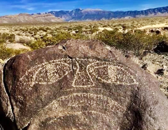
Petroglyphs are rock carvings (rock paintings are called pictographs). They are images created by removing part of a rock surface by incising, picking, carving, or abrading, as a form of rock art. In the U.S., most petroglyphs were carved by Native Americans. They often used a stone chisel and a hammerstone and often represent powerful cultural symbols that reflect the complex societies and religions of the tribes. Some of the petroglyph sites are fairly close to airstrips, making them easy for us to visit. This article focuses on New Mexico but, certainly, other states (such as Utah, California, Nevada, and Arizona) have plenty as well.
There are petroglyphs near the Carrizozo Municipal Airport (F37) in Carrizozo, New Mexico, or if you happen to find out who owns the “Three Rivers Airport,” in Three Rivers, New Mexico, maybe you can fly directly in there and walk over (about 2 miles). Inhabitants of a nearby village made the Three Rivers petroglyphs over 600 years ago. Over 20,000 petroglyphs have been identified in the area. The people were of the Jornada Mogollon (hor-NAH-da-muggy-OWN) prehistoric Indian culture, of which there are no known modern descendants. Some of the petroglyphs depict the animals and plants they saw around them; others had religious meaning.
Another cool site is Albuquerque’s Petroglyph National Monument, about 15 minutes from Double Eagle II Airport (KAEG). The three canyons to visit are:
• Boca Negra Canyon, where one can see 100 petroglyphs.
• Rinconada Canyon, where one can hike a 2.2-mile loop and see 300 petroglyphs.
• Piedras Marcadas Canyon, where one can walk 1.5-miles roundtrip, and see 400 petroglyphs.
Additionally, you can explore cinder cone volcanoes while there!
Crow Canyon, southeast of Farmington, contains the most extensive and well-known collection of 16th, 17th, and 18th century Navajo petroglyphs, as well as ruins. Aztec Municipal Airport (N19) or Four Corners Regional Airport (KFMN) are closest. However, note that a high clearance, four-wheel drive vehicle is recommended to visit the site.
El Morro National Monument in Ramah, N.M., has many Spanish and Anglo inscriptions and pre-historical petroglyphs, in addition to Ancestral Puebloan ruins and great views of the Zuni Mountains. Grants-Milan Municipal Airport (KGNT) is the closest public airport but, with prior permission, you may also be able to fly into the very scenic Mystic Bluffs Airport (NM56).
And, finally, the Rio Grande del Norte National Monument has petroglyphs as well. La Vista Trail, an easy 2.5-mile roundtrip, has plenty of petroglyphs and, if you time it correctly, you may even be able to go on a guided hike of it. The trailhead is on NM-567, about 0.5 miles west of the Taos Junction Bridge, which is 25 minutes from Taos Regional Airport (KSKX).
History defines where we came from! Go see it for yourself! Fly safe and fly often!
ABOUT THE AUTHOR: Yasmina Platt’s full-time job has her planning the future of aviation infrastructure for Joby’s electric Vertical Takeoff and Landing (VTOL) aircraft. She also writes an aviation travel blog called “Air Trails” (www.airtrails.weebly.com), in addition to articles on pilot destinations for Midwest Flyer Magazine. Pilots can locate articles Yasmina has written by going to www.MidwestFlyer.com and typing “Yasmina” in the search box, or by going to the “Archives” section, then “Columns,” then “Destinations.”