
by Patrick J. McDonald, ATP CFII
© Copyright 2022. All rights reserved!
Published in Midwest Flyer Magazine December 2022/January 2023 Digital Issue
The word, derecho, is fairly new to our pilot weather vocabulary. The word, Spanish in origin, literally means “straight ahead.” The word attempts to convey a notion that as a derecho builds in magnitude, the winds surge forward in a straight line – rather than through the spinning phenomenon of a tornado.
My first encounter with a derecho was on the morning of August 10, 2020, when the now-named Heartland Derecho wreaked havoc in the Midwest.
I’m a mental health practitioner and I was working in my office with a client that morning. I heard no tornado warnings, but I did hear the rush of heavy winds and the crashing of tree branches. I turned toward the window and tried to catch a first glimpse at what was going on. The immediate impression was that of a bright neon-like green sky, emerging from the west. Then I saw a mature tree go down, taking out a neighbor’s fence, followed by a storm of asphalt shingles and splintered pieces of roof support peppering my parking lot. I somehow knew that the broken building products came from the roof of a large sports arena several blocks away.
The wind picked up intensity over the next 15 minutes as the rain thickened. It grew darker, but the sky still remained a haunting green color. Both my client and I expressed our fears, noting that we had never experienced anything like this – ever!
As the rest of the day unfolded, I participated in the widespread clean-up efforts in our community. The cleanup crews were shakened by stories of damage from as far away as Illinois. Every TV report noted that the culprit was not a tornado, but a derecho with straight-line winds howling up to 140 mph.
I remember remarking to my client that I was happy to be ground-bound, rather than fighting something as destructive as this event in a small plane. He laughed and agreed. I would never have deliberately bargained for an encounter with this much destructive energy, but my opportunity to bump up against a derecho came on the morning of July 5, 2022.
Out of Billings, Montana
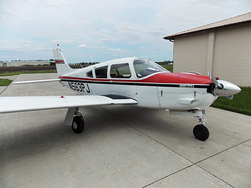
By 10:00 a.m., my brother and I are at Billings, Montana’s Logan Airport, waiting for some low ceilings in Sheridan and Rapid City to lift, opening up an undisturbed flight home to Des Moines. We had just spent a carefree week whitewater rafting in the magnificent Salmon River country of Idaho. Our flight home is programmed to become the last chapter of a grand summer adventure. The only hint of a potential weather problem is clearly visible on a Sirius XM weather presentation as we sit in my Piper Arrow, waiting for an IFR clearance to Rapid City.
The full-color weather pictorial shows two clusters of morning thunderstorms 100 miles away, approaching Miles City, Montana. The weather is moving in a northeasterly direction – away from our route of flight. “Nothing to worry about,” I reassure my brother.
We are soon in bright sunshine at 10,000 feet. Clouds are now obscuring the Black Hills in multiple layers below us, down to 800 feet above the ground into our Rapid City fuel stop. I had filed for Chadron, Nebraska, as an alternate – another 75 miles to the southeast. On my weather pictorial and from my observation, all of Nebraska was clear with good visibility. About the same time that Ellsworth Approach Control advised us to expect a GPS 32 approach to Rapid City, our situation changes dramatically.
The same early-morning thunderstorm area that prompted us to fly southeastward to Rapid City has now tripled in size. It blatantly presents itself as one massive patch of red, laced throughout with lightning bolt images and severe storm boxes – stretching from eastern Montana to the edge of the Black Hills to well past Pierre, S.D.
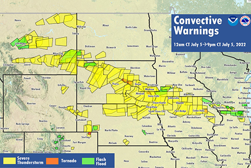
![]()
I also see a haunting green hue to the wall of water that is now clearly visible and converging on my left flank at a frightening closing speed. It is the same menacing green color of the derecho that assaulted my office two years ago.
I know that I can get into Rapid City with some difficulty, but I’ll likely get stuck there in violent weather conditions. I request to proceed to my Chadron alternate and receive an immediate clearance from air traffic control.
Chadron AWOS reports hot and clear with winds now at 050 degrees at 37 knots and gusts to 43. Runway 3 gives me some edge on the crosswind component, but my final approach is rocky, punishing us with constantly changing wind sheer, but we land safely.
As we shut down at the fuel pump, the fixed base operator asks us how the ride was. “Miserable – but I landed safely,” I answered.
“Gets hot and windy around here during the summertime,” he said as he assisted us in our refueling chore. “Lotsa deviations today. I hear we got real bad weather in the Black Hills,” he commented. Before I could answer, he continued, “You better not hang around here too long,” as he pointed to another thunderstorm cluster to our south, now starting to crowd our right flank.
Out of Chadron, Nebraska
The climb-out from Chadron is hot and rocky but good VFR. We are now starting to get squeezed between two systems. The massive green wall on our left flank has now passed Rapid City and is rushing along Interstate 90 toward Mitchell.
The new Nebraska system crowding our right flank defines one side of a corridor that is growing tighter by the mile. My XM weather depiction shows moderate rain showers for the next 20 miles, then clear weather to the southeast toward Lincoln. I calculate that I should escape the narrowing cumulus corridor in 40 more miles. Progress is incredibly slow at 89 knots.
I listen to Denver Center Flight-Following and hear others complain about the conditions. One pilot report, in a thin voice, that he’s encountering severe turbulence at O’Neill, Nebraska (to our south). “Do you need help? Is anyone hurt?” queries the controller. “No one’s hurt,” says the pilot. “We seem to be out of it, but we got some real headaches.”
About that time, as we turn the corner to stay out of heavy rain, it is our turn to encounter severe turbulence. We are already cinched in tight with lap and shoulder harnesses, so no head injuries occur. Our luggage bags lift and reposition themselves several times – fortunately not on top of us. Neither of us say anything. For three long minutes, we struggle to maintain a stable flight attitude, but are essentially helpless to do much except ride out the bumps and hope nothing breaks.
Then in another pleasant surprise, the air unexpectedly calms and cools by 15 degrees. Our groundspeed increases to 170 knots. The massive increase in groundspeed is a real bonus for us. We are now riding in a fast-moving column of air that is part of the derecho’s elusive alchemy, while benignly getting pushed away from the destructive interior weather system’s wreaking havoc through its core.
Our ride feels secure for the moment, and it now looks like we can flank this green monster all the way to our home base. By monitoring ground stations, I monitor a broad trail of large hail, 80-knot winds, and torrential rains across South Dakota, into Nebraska, then Iowa. The green wall of destruction is moving steadily toward our home base, but all calculations indicate that we should arrive there first.
Out of Energy
I confirm my calculations as we land in seven knot winds and hurriedly park our aircraft, while keeping our eyes on the western horizon. The ugly green color is deepening. A dense wall of water is no longer flanking us. It is pursuing us from straight out of a westerly heading. Happy to be ground-bound, we debrief over a beer in a local watering hole as we listen to the weather roll over the top of us.
Heavy rains and wind last for a solid hour. Some trees go down. My hangar sustains no wind damage. We drink another toast to being ground-bound and seemingly safe for the moment.
It takes a number of hours, even days, to construct some credible image of what happened as we flanked this massive phenomenon. I learned through a little research that the ugly green color comes from the refraction of sunlight through a high volume of hail. The National Weather Service released this interim Tweet on July 6th:
“After discussing with SPC, today’s still ongoing thunderstorm complex will be considered a derecho. The peak winds so far have been 96 mph in Huron, S.D. and 99 mph near Howard, S.D., but there have been many high wind reports.”
One friend, who lives 100 miles to the north of Des Moines, remarked: “The storm blew the roof off my new home, but no one got hurt.” Another friend observed a week later, “Hey, I was on a motorcycle trip to the Black Hills. We got hung up there in a terrible storm the day after the Fourth of July. We headed out the next day down Interstate 90 and every directional sign along the interstate highway was flattened from Rapid City to Mitchell. Devastation.”
I’m still pondering the same question that stimulated this reflection… Would I rather be ground-bound and seemingly safe or view a derecho from a small plane?
I’ll take the small plane, with a few qualifiers. I would never set out to challenge a storm of this magnitude. I was, by fate, invited to view a powerful mix of the forces of nature, and I’ll never forget the experience. I also learned that violent turbulence awaits an innocent pilot 40 miles from the edge of this green monster. I knew I could take a more dramatic turn and escape the destruction. Now, in retrospect, I can only say that once in a lifetime is enough.
EDITOR’S NOTE: Patrick J. McDonald has been a member of the aviation community for 53 years and in that period, he has logged over 8,000 hours. He has helped many students to obtain various flight certificates and has done it all for pure enjoyment. McDonald is formally a licensed mental health practitioner and maintains an active practice in Des Moines, in partnership with his wife of 47 years.